The earliest Armenian geographic work is the seventh-century manuscript entitled Ashkharhatsuyts (Mirror of the World), penned most probably by the Armenian mathematician, scientist, and geographer Anania Shirakatsi (Anania of Shirak). This work was originally attributed to the fifth-century Armenian historian Movses Khorenatsi, but research has shown that it most probably belongs to the pen of Shirakatsi. Research indicates that it has many similarities with the Geographia of Claudius Ptolemaeus (c. 90-168) better known as Ptolemy as well as referring to the work of Pappus of Alexandria, who also used Ptolemy’s works.
The reference to the work of the sixth-century scholar and traveler Cosma Indicopleustes possibly confirms that it most probably was written after Khorenatsi, who lived and worked during the fifth century. The work describes and lists the names of various countries, cities and natural landmarks. However, it is not known whether any maps accompanied the manuscript since none have reached us. Therefore it must be assumed that most likely the Ashkharhatsuyts is a purely geographical text.
The manuscript also includes a list of important routes for travelers, specifying distances between main towns and cities, which makes it some sort of a mileage chart.
The first medieval Armenian World Map
Among the Matenadaran collection, there is a small volume, numbered MS 1242, which is a collection of eighteen separate articles on religious, moral, mathematical and astronomical subjects, dating mainly from the thirteenth to the fifteenth centuries.
The manuscript is prepared in one of the Armenian scriptoria in Caffa (present-day Theodosia/Feodosiya in Crimea). On folio 132a, inserted between a circular “table of the solar orbit” and an article on mathematical riddles, there is a circular world map. This map is drawn as a standard European religious T-O type map, in line with many of its kind, this is the only Armenian T-O map known so far.
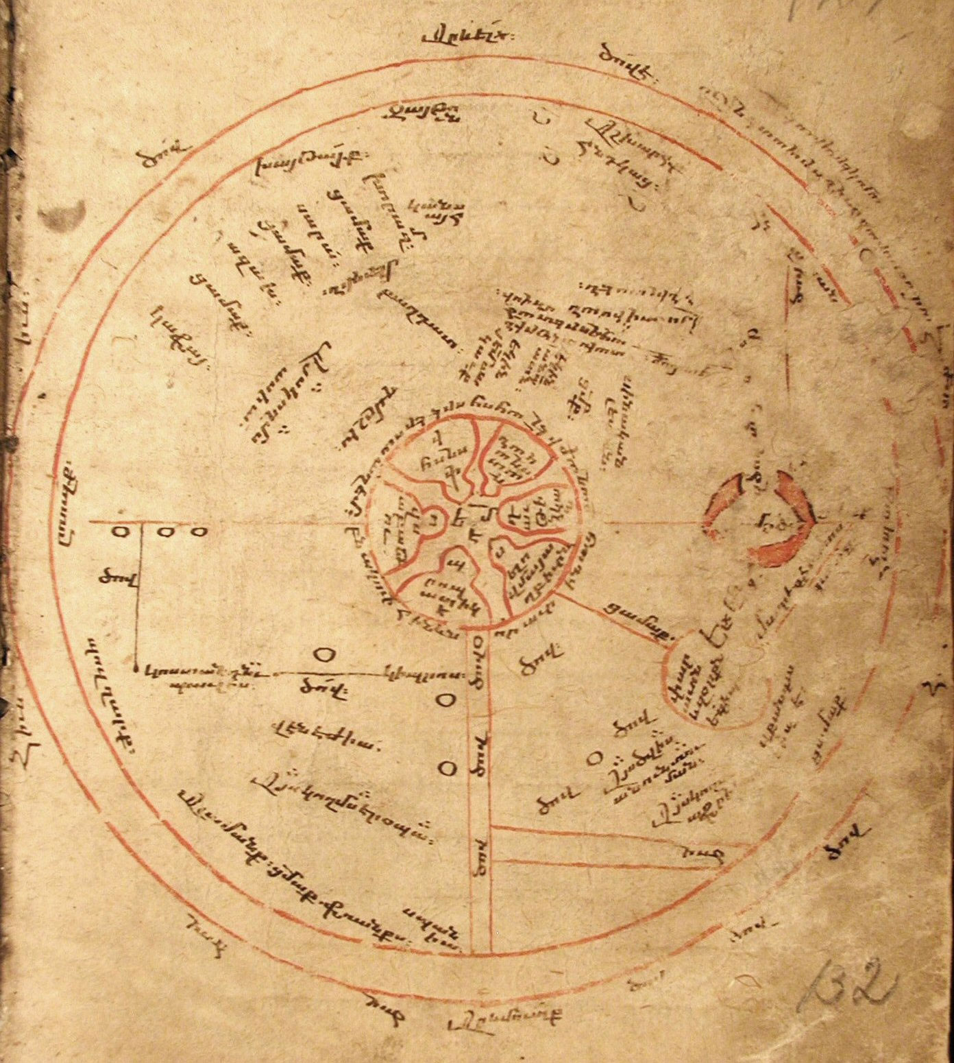
This small map was made at the end of the thirteenth and the beginning of the fourteenth centuries is the oldest Armenian language document that could be called a map. The map is circular, with the external circle measuring 125mm in diameter.
As in many T-O maps of its time, the center of the map is occupied by the Holy City of Jerusalem, which is shown with its six gates, inscribed with their Armenian names. The extra attention paid to Jerusalem, the Holy Land and other Biblical landmarks is typical of the T-O type maps of the time, attributed to the Christian religious origin of these maps. In Armenian cartographical circles, these maps are known as “psalter” maps.
Apianus
A manuscript in the Matenadaran (reference MS-1780), dating from 1617 and 1621, includes the translation of one of the important geographical works, Ptolemy’s Geographia and Petrus Apianus’s (also known as Peter Apian, 1495-1552) Cosmographia.
In the manuscript, there are a number of maps from Apianus’s work, which have been translated and redrawn. This is one of the important geographical manuscripts in the Matenadaran. Apianus was a German humanist, astronomer, geographer, and mathematician. His most important work is the publication of the volume entitled Cosmographicus liber in 1524, also known as the Cosmography. The book was reprinted many times as well as having being translated into over ten languages.

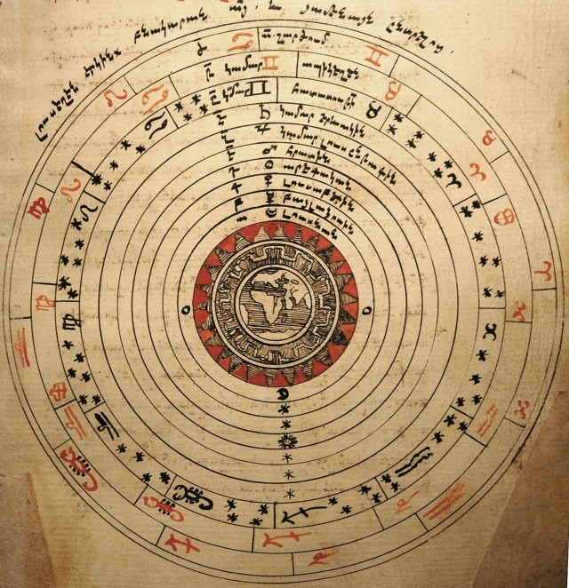
The map above shows our solar system (or rather “earthly” system, since it is depicted as a geocentric one) of planets, which has the Earth at its center and depicts the planets according to Ptolemy. This map has a large sphere of the Earth in its center, around which all the planets, as well as the sun and moon, revolve. The Earth is represented with the eastern hemisphere shown as it was imagined at the time.

The legend around the map above states that the circumference of the map equals to 5,400 German miles, which is 39,520 kilometers (each German mile is around 7,320 metres). This is a very good approximation even by the present-day standards.
The Earth’s circumference at the Equator and the poles varies from 40,055 to 40,253 kilometers.